
Climate · Hurricanes · Weather · Gulf of Mexico
Tropical Storm Isaias: forecast to become a hurricane and approach the US Gulf Coast
 Illustration
Closed: we stopped updating this record on 7 October 2026. For current forecasts and warnings, follow the US National Hurricane Center.
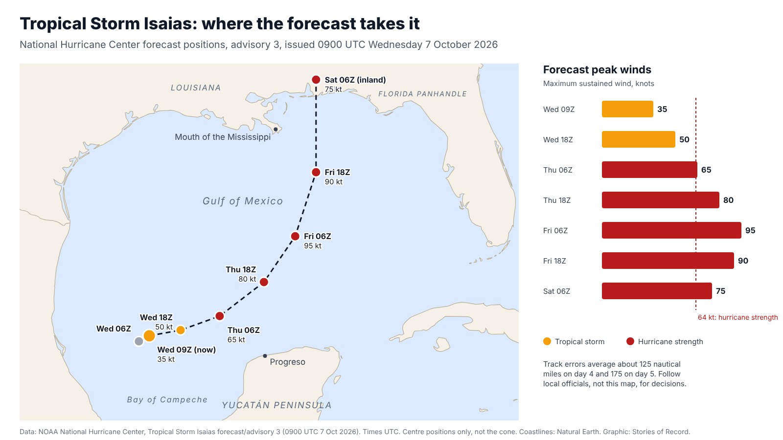
Tropical Storm Isaias formed in the southern Gulf on Wednesday morning. The National Hurricane Center expects rapid strengthening, a hurricane by Thursday, and an approach to the US northern Gulf Coast on Friday, possibly as a significant hurricane. Heavy rain is forecast from far southeastern Louisiana to the Florida Panhandle, and hurricane and storm surge watches are likely.
Latest update
This record is closed and no longer updated. Live storms are outside what Stories of Record covers. Everything below is as last verified at 09:06 UTC on 7 October 2026, so it may be out of date. Follow the US National Hurricane Center for current forecasts and warnings.
What changed in this version
Version 2, : Record closed: no longer updated, because the topic is outside the areas Stories of Record covers.
Key facts
- The National Hurricane Center forecasts rapid strengthening, with Isaias becoming a hurricane by Thursday. [2]
- The forecast track takes Isaias north of the Yucatán Peninsula on Thursday and towards the US northern Gulf Coast on Friday, with the centre inland by early Saturday. [2] [3]
- From Friday through the weekend, 3 to 6 inches of rain are forecast from far southeastern Louisiana to the Florida Panhandle, locally up to 10 inches, with flash and urban flooding possible. [2]
Timeline
- Tropical Depression Nine strengthened into Tropical Storm Isaias over the southern Gulf, with maximum sustained winds near 65 km/h (40 mph). [2] [1]
- Tropical Depression Nine formed over the southern Gulf on Tuesday, with the hurricane center's first advisory at 2100 UTC giving maximum sustained winds near 55 km/h (35 mph) and forecasting it to strengthen quickly. [1]
What is confirmed
- Tropical Depression Nine formed over the southern Gulf on Tuesday, with the hurricane center's first advisory at 2100 UTC giving maximum sustained winds near 55 km/h (35 mph) and forecasting it to strengthen quickly. [1]
- Tropical Depression Nine strengthened into Tropical Storm Isaias over the southern Gulf, with maximum sustained winds near 65 km/h (40 mph). [2] [1]
- At 0900 UTC the centre was about 460 km (285 miles) west of Progreso, Mexico, and 935 km (580 miles) southwest of the mouth of the Mississippi River, moving east-northeast at about 13 km/h (8 mph). [2]
- The forecast peak is 95 knots (110 mph) over the central Gulf early on Friday. Wind shear is forecast to rise sharply before landfall, but the hurricane center now says Isaias is increasingly likely to be a significant hurricane when it reaches the coast. [3] [4]
- No coastal watches or warnings were in effect, but the hurricane center said hurricane and storm surge watches will likely be needed for part of the northern Gulf coast later on Wednesday. [2] [4]
- Coastal parts of the Bay of Campeche could get 2 to 4 inches of rain through Thursday, and swells are expected to cause life-threatening surf and rip currents on the Yucatán Peninsula and later the Gulf Coast. [2]
- The hurricane center rates its confidence in the track as below average because models disagree widely, and its latest track moved east compared with the previous one. [4]
- The hurricane center notes that its track forecasts have erred by about 125 nautical miles on day 4 and 175 on day 5 on average. [3]
- Sea-surface temperatures of 30 to 31 °C and plenty of moisture favour strengthening in the short term. [4]
What remains unconfirmed
No open questions are being tracked.
Why it matters
Residents and businesses from Louisiana to the Florida Panhandle may face hurricane winds, flooding rain and dangerous surf from Friday into the weekend. Parts of Mexico's Yucatán Peninsula and the Bay of Campeche coast could see heavy rain and rough seas first.
What happens next
- : The hurricane center's next full advisory is due at 1500 UTC. [3]
- : Hurricane and storm surge watches are likely for part of the northern Gulf coast later on Wednesday. [4]
- : Air Force Reserve and NOAA Hurricane Hunter aircraft are scheduled to fly into the storm later on Wednesday. [4]
Questions
Where is Tropical Storm Isaias now?
At 0900 UTC on Wednesday it was about 460 km (285 miles) west of Progreso, Mexico, moving east-northeast at about 13 km/h.
Will Isaias become a hurricane?
Yes, according to the forecast. The National Hurricane Center expects rapid strengthening, a hurricane by Thursday and a peak near 95 knots (110 mph) over the central Gulf early on Friday.
Where could it make landfall?
The forecast takes it towards the US northern Gulf Coast on Friday and inland by early Saturday. The hurricane center rates its track confidence as below average, so the exact landfall point is still uncertain.
How much rain is forecast?
From Friday through the weekend, 3 to 6 inches from far southeastern Louisiana to the Florida Panhandle, locally up to 10 inches, with flash and urban flooding possible.
Are there any warnings?
Not yet. No coastal watches or warnings were in effect, but hurricane and storm surge watches are likely for part of the northern Gulf coast later on Wednesday.
Sources
- Tropical Depression NINE, National Oceanic and Atmospheric AdministrationOfficial (government)Accessed 7 October 2026.
- Tropical Storm Isaias Public Advisory, National Oceanic and Atmospheric AdministrationOfficial (government)Accessed 7 October 2026.
- Tropical Storm Isaias Forecast Advisory, National Oceanic and Atmospheric AdministrationOfficial (government)Accessed 7 October 2026.
- Tropical Storm Isaias Forecast Discussion, National Oceanic and Atmospheric AdministrationOfficial (government)Accessed 7 October 2026.
People, places and organizations
- organization
- National Hurricane Center
- location
- Yucatán Peninsula
- location
- Gulf Coast of the United States